← Home · In-Situ Testing

Field Density Testing (Sand Cone Method) in Cheyenne, WY

Together, we solve the challenges of tomorrow.

LEARN MORE →

Cheyenne’s development pattern, stretching outward from the historic Union Pacific rail yards into the rolling shortgrass prairie, has placed unique demands on earthwork quality control across the High Plains. The shallow bedrock and expansive clay lenses found throughout Laramie County mean that structural fill performance cannot be left to chance, particularly where freeze-thaw cycles penetrate three to four feet annually. Our materials testing laboratory has supported this growth by providing precise Proctor tests to establish target density values and the corresponding sand cone field verification, ensuring that compacted lifts under commercial pads along Dell Range Boulevard or residential subdivisions near Saddle Ridge meet specification before concrete is ever poured. At 6,062 feet of elevation, the semi-arid climate accelerates moisture loss from borrow soils during summer grading, making real-time density checks a critical part of the construction sequence. We also integrate Atterberg limits analysis when field moisture readings suggest that native fines are responding differently than the proctor curve predicted.

A sand cone test that passes at 95 percent modified Proctor but loses moisture overnight will fail re-inspection after the morning freeze—timing matters as much as technique on the High Plains.

Our approach and scope

ASTM D1556-15 and AASHTO T 191 govern every sand cone test performed by our field technicians, but compliance in Cheyenne requires adapting to site conditions that standard manuals do not fully address. The region’s well-drained sandy loams overlying weathered Pierre Shale can produce density gradients within a single six-inch lift if the contractor’s water truck application pattern is uneven, a scenario we catch by running paired tests at staggered locations rather than relying on a single pass-fail reading. Calibration of the Ottawa sand—specifically its bulk density and cone correction factor—is repeated whenever the sand lot changes or humidity swings more than 20 percent, which happens regularly between morning and afternoon shifts during August grading operations. For roadway subgrade on WYDOT-administered projects, we often sequence the sand cone with CBR testing to correlate in-place density with bearing capacity before aggregate base placement begins. The laboratory maintains AASHTO re:source accreditation for soil testing, and all field density reports include the elevation, stationing, lift number, and proctor reference curve so that the geotechnical engineer can immediately assess compaction trends across the site.
Field Density Testing (Sand Cone Method) in Cheyenne, WY
Technical reference image — Cheyenne

Local ground factors

One recurring failure we encounter on Cheyenne job sites is the assumption that a nuclear gauge reading can substitute for a sand cone verification without cross-calibration on the specific borrow source. Several high-plasticity clay fills near Crow Creek produced nuclear densities that read 4 to 6 percent higher than the corresponding sand cone values because the gauge’s factory calibration did not account for the bound water in smectitic clays derived from local Pierre Shale. When the structural engineer rejected the fill based on our sand cone results, the contractor lost two weeks removing and recompacting lifts that had already been covered by subsequent layers. Another frequent issue involves testing immediately after a heavy thunderstorm, which can saturate the upper crust of a compacted lift while the underlying material remains at optimum moisture; the sand cone captures an average that misrepresents both zones unless the technician trims the test hole with careful depth control. On fast-track commercial projects near the Cheyenne Business Parkway, we schedule density tests to coincide with the scraper fleet’s cycle time so that failing zones are reworked before the next lift arrives, preventing costly re-excavation later. The slope stability implications become acute when under-compacted fill is placed against foundation walls or abutments, where lateral earth pressures can trigger movement if the backfill consolidates under its own weight over the first winter.

Need a geotechnical assessment?

Reply within 24h.

Email: contact@geotechnicalengineering.sbs

Typical values

ParameterTypical value
Test standardASTM D1556-15 / AASHTO T 191
Applicable soil typesCoarse-grained soils up to 1.5 in particle size; not for saturated or highly plastic clays
Maximum test depthTypically 6-8 inches (single lift verification)
Cone sand specificationGraded Ottawa sand passing No. 20, retained on No. 30 sieve
Typical test frequencyOne test per 1,500-2,500 sq ft per lift; higher frequency in utility trench backfill
Reported parametersWet density, dry density, moisture content, percent compaction vs. Proctor reference
Key interference in CheyenneWind exceeding 15 mph can disturb sand pouring; shielded enclosures used when necessary

Associated technical services

01

Sand Cone Density Testing

Field determination of in-place soil density per ASTM D1556 on structural fill, utility trench backfill, and pavement subgrade. Includes moisture content determination by Speedy moisture tester or laboratory oven drying, percent compaction calculation against the project Proctor curve, and a stamped field report with GPS coordinates and lift identification.

02

Compaction Control Package

Combined laboratory and field program beginning with modified or standard Proctor testing (ASTM D1557/D698) on the contractor’s borrow source, followed by scheduled sand cone density tests during fill placement. We provide a compaction curve sheet that the superintendent can reference in the field, and our technicians note any changes in soil classification that would require a new proctor.

Regulatory framework

ASTM D1556-15, AASHTO T 191, ASTM D698 / D1557 (Proctor reference), WYDOT Standard Specifications Section 203

Quick answers

How much does a sand cone density test cost on a Cheyenne project?

A single sand cone field density test with moisture content determination typically ranges from US$90 to US$160 depending on travel distance within Laramie County, the number of tests scheduled per visit, and whether laboratory oven drying is required for the moisture sample. We recommend scheduling multiple tests on the same mobilization to reduce the per-unit cost.

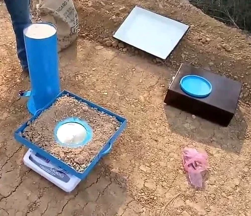
What soil types can be tested with the sand cone method?

The sand cone method works best on coarse-grained soils with maximum particle sizes up to about one and a half inches, including sands, gravels, and low-plasticity silts. It is not suitable for saturated soils where water flows into the test hole, nor for highly plastic clays that deform during excavation of the hole. For those conditions we may recommend alternative methods or careful hand-trimming of the test cavity.

How often should field density tests be performed during fill placement?

The standard specification calls for one density test per 1,500 to 2,500 square feet per compacted lift, though frequency increases in utility trench backfill zones and around foundation perimeters. On WYDOT projects, the specification may require as many as one test per 500 square feet for mechanically stabilized earth backfill, and we coordinate with the contractor’s quality control schedule to avoid delays.

Can the sand cone test be used in freezing conditions?

Testing frozen soil is not permitted under ASTM D1556 because ice lenses alter both the volume measurement and the moisture content determination. During Cheyenne’s winter construction season, we monitor ground temperatures and postpone density testing when frost penetration exceeds one inch. Contractors working under cold-weather provisions typically protect the fill with insulating blankets and schedule tests during the warmest part of the day.

Location and service area

We serve projects across Cheyenne and surrounding areas.

View larger map